 Live Music Archive
 Librivox Free Audio
 Metropolitan Museum
 Cleveland Museum of Art
 Internet Arcade
 Console Living Room
 Books to Borrow
 Open Library
 TV News
 Understanding 9/11
tv Piers Morgan Tonight CNN October 30, 2012 12:00am-1:00am PDT
12:00 am

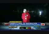
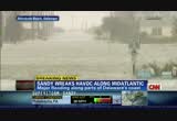
live reports up and down the east coast as sandy continues to rip down power lines and flood streets and communities and cause those evacuations. >> we continue to watch this dangerous storm all long. the next hour of the cnn special coverage of the superstorm sandy begins right now. it is now 3:00 in the morning here on the east coast. we have reporters up and down the east coast bringing us the latest developments all over how long. look how posteriorful it is, ripping down trees, crushing cars. at least 13 people dead. five in new york as we've said.
12:01 am
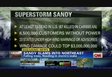
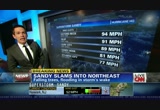
the number now customers without power, up to 6.5 million. we've talked about this as a northeast and mid-atlantic storm but 23 states under high wind warnings are advisories right now. cnn estimates that the wind alone could cause damage upwards of $3 billion. already 67 people killed in the caribbean. >> and then take a look at this, what's become a fairly common scene, unfortunately. roads flooded. the water rising nearly above a lot of cars that are parked there. approximately seven, almost eight hours ago this historic superstorm made landfall over the most populated areas of the united states. wind damage, power outages, storm surges, inland flooding, even snowstorms are threatening the lives and homes of 60 million people from virginia to massachusetts. >> we've been doing this for several hours but this is something we have to continue to watch. a live look now at that crane that broke earlier this -- well,
12:02 am
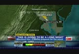
yesterday now. about 12 hours ago. so, above a building, west 57th street in new york. the boom is just swinging there. and could fall at any moment. we're going to continue to watch it until it's secured. how long it can hold up, no one knows. let's check in with meteorologist ivan cabrera right now on the superstorm. we talked about the rain and the wind, but what is really intriguing is the snow that is falling and that will continue to fall. and this thundersnow in western maryland and west virginia. >> you name it. we have every single meteorological event going on here for just one storm. it's an incredible feature, which is marry a hurricane which killed dozens of people in cuba and jamaica. we've been tracking this storm for quite some time and it merged with midlatitude cyclone and now the superstorm, as you mentioned, creating blizzard conditions in the virginias.
12:03 am
even the thunderstorm activity up into maine with heavy rainfall throughout. i can show you the satellite and show you the radar. we'll fly in here. it's hard to tell what's happening on the ground because it is dark. we still have a few hours before daylight. sun-up is not until 7:24 in new york city. that's when we will get a few scope of what's been happening here on the ground with the flooding as far as not only in battery park but, of course, also in the subways. here's baltimore and washington getting in on heavy rain bands. these yellow bands can contain tropical storm wind gusts, 45 to 50 miles an hour. the other side of the story is the snow that is going to continue to fall. this entire snowstorm and event is not going to be done until wednesday. we'll be dealing with some kind of flooding, some wind damage, river flooding is going to continue and all of this is going to be pushing to the west.
12:04 am
we are done with wind gusts, almost category 2 at eatons neck. we won't see that. we're seeing some better news. we are seeing good news. we have high wind warnings continue, gusts up to 60. and also oon some lake-enhanced snow. that's what we're talking about off great lakes as well. that's how cold the air is. cold enough for snow, 16 inches already in snowshoe, west virginia. thank you, they're saying there, because that is a ski resort, so they're very to go in and around and drive around, it is not going to be pretty at all. we have another 2 to 3 feet.
12:05 am
that's total forecast here. that's the worst of it here. we see the purple but you see the snow extends further to the north and west. blizzard warnings are still flying. this is the amazing thing as far as this once hurricane, now full-blown nor'easter producing blizzard conditions as well. a long duration event. for the east coast we'll begin to wind things down for today, later on this evening. and then really get into the clear by wednesday. take a look at temperatures here. what is it now, 7 million people? >> 6.5. >> 6.5 million without power. i guarantee you they are going to be very chilly tonight. look at overnight temperatures. we'll be dropping into the upper 30s to low 40s. in your house, if it gets cold that is going to make for a very
12:06 am
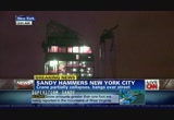
uncomfortable night whether you're outside, and hopefully you're not if you don't have to be. but even for those folks that are inside that are likely not watching us right now because they've got no power. >> yeah. and -- >> especially sad is this is the time when people start those creative and unsafe ways to try to stay warm because they're without power. >> good point, yeah. >> and of course the power companies will tell you it's going to take some time. they have to assess before they can actually address how to get the power back on. so we're talking about 6.5 million people now. and we're hearing updates almost every hour. so it's unclear whether we are going to get to that number that ivan just mentioned, 7 million. many of the tens of thousands of people who are without power are actually in lower manhattan and staten island. a transformer exploded there, and con edison is maintaining that it happened at that 14th street plant. you're going to see it right there, caught on video. a con edison vp says workers don't know exactly what caused
12:07 am
that massive blowout. but we're not just talking about new york city. just take a look at all the states here that are impacted by the power outages amounting to these nearly 7 million people without power. nearly 3 million people in new york and new jersey alone have lost power. the most populous areas. >> we have karen sketcher on the phone right now. she's the communications officer with the red cross. she is in peoria, illinois. karen, we understand that because of sandy the red cross has had to cancel blood drives. and especially this time of year with or without a storm it's something you never want to hear. how many people are affected? >> well, at this point the need for blood is constant. it's always constant. and with the cancellation of about 100 american red cross blood drives in 11 states on the east coast roughly 3,200 people have not been able to keep their
12:08 am

blood or platelet donation appointments. and that's pretty significant when you think about the fact that nationwide we need about 44,000 blood donations each and every day just to meet the needs of all different types of patients. 3,200 blood donations is a pretty significant number. >> and with the evacuations of hospitals and we've talked about deaths, but there are also injuries, people will need blood transfusions, how long do we expect these cancellations to last? >> as long as the severe weather continues we can expect blood drive cancellations to continue as well. things like power outages, the winter storms, the flooding, all of those will mean that schools, churches, businesses will not be able to host blood drives. and certainly folks in the impacted areas are going to be trying to rebuild their lives. they won't necessarily be able to come out and give blood. which is why it's so important for everyone in unimpacted areas
12:09 am

to step up and give right now. >> and what's the best way to give? >> give us a call or go online. we try to make it as convenient as possible. there are many, many blood drives nationwide. so it's easy to find one that's near you. you can give us a call at 1-800-red-cross. you can go online to redcross.org or redcrossblood.org and find a blood drive near you. >> all right. karen stecher, red cross communications officer, talking about the need to help our neighbors, whether they're across the city or across the country. a lot of people after superstorm sandy will need some help. karen, thank you so much. let's turn to new york city, where sandy has shut down air travel. shut it down. newark, kennedy, laguardia, all closed. an industry website estimates that 13,000 flights have been canceled since saturday. and a lot of carriers are allowing passengers to change their itineraries without having to pay a fee.
12:10 am

but you have to check with your airline for details. amtrak has extended cancellations for much of its northeast corridor through tomorrow, but trains coming to and from canada or to and from the south will still operate. however, they will end their routes before they reach states affected by sandy. all right. our team coverage of this superstorm sandy continues straight through the night. >> yeah. live reports, new details, tracking the storm, the rain, the snow, the wind, all of it. we'll be right back. ny unstopabs in-wash scent boosters, here with my favorite new intern, jimmy. mmm! fresh! and it's been in the closet for 12 weeks! unbelievable! unstopables! i'll show you how! ♪ just shake them into the washer i can't believe this lasts 12 weeks! neither can they. so you're going on tour to prove it. downy unstopables. follow jimmy's unstopables tour on youtube.
12:11 am

downy unstopables. the wheels of progress. seems they haven't been moving much lately. but things are starting to turn around because of business people like you. and regions is here to help. with the experience and service to keep things rolling. from business loans to cash management, we want to be your partner moving forward. so switch to regions. and let's get going. together.

12:13 am
flood waters continue to pour into lower manhattan. that's where we find chris welch. chris, any progress there? >> reporter: fredricka, a few minutes ago i heard you talking about that transformer explosion that we've sort of been
12:14 am

discussing here tonight. that is very near where i am here in the lower east side of manhattan. we're at about east houston and avenue d streets. and that transformer went out, oh, about i guess it would be about three or four hours ago at least now. and i've heard from several folks in the area who say they heard loud bangs, they saw flashes of light-k and then darkness. so that transformer services these people in this neighborhood where i'm standing right now. so everywhere it's dark. this is not a sight you usually see on the lower east side of manhattan in new york city. currently the water where um standing is maybe at my ankles but when we were here earlier about three hours ago where i'm standing right now was probably about right about here. and if you look behind me you can see sort of a minute i why van ther mini van there. the water was up to probably the headlights. there were several cars parked there. since we've been here for several hours the wind and the rain has kind of come and gone. we've had periods of calm -- and
12:15 am

it's really gotten quite chilly. but other than that this water, as i mentioned, has gone down quite a bit. but i want to say it seems like at least if it's not stopped altogether it's slowed -- the receding has slowed down severely. at least where we are standing for the present time. fredricka. >> and then again we understand that a high tide, which is roughly about 9:00 a.m., that could change the dynamic of things as well. chris welch, thanks so much. in lower manhattan. so sandy is forcing the evacuation of more than 200 patients from nyu's medical center, not far from where chris is. as they are being transferred right now to other facilities because nyu's hospital lost generator power. earlier i spoke to senior medical correspondent elizabeth cohen about the situation unfolding. >> they are in the middle right now as we speak of evacuating 260 patients, approximately. at around 7:00 they went from having no water in their
12:16 am

building to 45 minutes later having more than ten feet of water. so they are now carrying patients down 15 flights of stairs, sometimes only with flashlights to illuminate the way. this evacuation includes an intensive care unit, a neonatal intensive care unit, and a pediatric intensive care unit. those are the sickest patients, fredricka, and we're told that those patients are all out. now, four of those newborn babies were on respirators that were not working because there was no power. so the whole time that they were taken down, about nine flights of stairs, a nurse had to do what's called bagging. a nurse would manually pump oxygen so that the child could breathe, the baby could breathe. they anticipate this evacuation will take another five hours. >> wow. sandy ripping through a wide swath of big cities all up and down the east coast. but then i look at the situation state by state. let's go to connecticut first. this is the situation right now.
12:17 am

sandy has killed at least one person and injured two others in connecticut. entire waterfront communities submerged underwater, and more than 639,000 people are without power there. the already high storm surges from sandy are only being made worse by the full moon. and governor dan malloy says authorities are bracing for surges up to 11 feet above normal high tide. the governor says connecticut could potentially face unprecedented damage. >> this is the most catastrophic event that we have faced and been able to plan for in any of our lifetimes. >> we head back to new york. sandy is being blamed for at least five deaths there. >> a spokesman from governor cuomo's office says one of the victims died when a tree fell on his home in queens. and also in queens a woman was electrocute when'd she stepped into a puddle. >> jason carroll has a look at things now in long island. >> reporter: well, it's now well after midnight.
12:18 am
the wind has still picked up. but the water at least has receded. just about an hour ago i could not have stood in this section of the montauk highway without the water not being up to knee level. but now you can see it has receded. but if you stare into that blackness off to my right, this is one of many streets that still feed into the montauk highway, and those streets are still flooded, but again, the water has started to recede. some of the issues that they've been dealing with here in lindenhurst is not just flooding but also fires. we've reported at least several house fires in the area. electrical fires sparked by the flood waters. they've had to deal with that, putting out those fires throughout the -- throughout the day and into the evening. they'll be working into tomorrow morning as well, assessing the damage here. we're expecting when we see the light of day tomorrow that there are going to be dozens of homes
12:19 am

here in the south shore that are dealing with flooding as residents who were under mandatory evacuation and heed the warning finally start to return to their homes tomorrow. as you can see, some of the emergency crews now still coming through here, assessing the area, trying to keep people out and picking up those last-minute folks who decided they were not going to evacuate, trying to help them as well. so it's been a long night for the residents here in lindenhurst. it's going to be a long morning tomorrow as well. back to you. >> jason carroll, thank you very much for that. this is going to be a long night. words from maryland governor martin o'malley earlier tonight. and now, thankfully, the storm is moving out of the area, and the worst is over for maryland. but maryland remains under a state of emergency. and we're getting word that a power outage, as water reclamations created an active raw sewage leak in howard county. according to state officials there are a total of about 365,000 power outages in
12:20 am
maryland. of course, we're watching that leak of raw sewage. we'll get updates on that. massachusetts also under a state of emergency. severe wind is the big concern there. 354,000 people are without power right now. there was criticism after last year's hurricane irene. remember that? but the governor said utility and power companies will be working together to be more efficient. you see this video of that boathouse that succumbed to the winds and water of sandy. schools in boston were closed. and all public transportation was suspended today. and the streets are flooded, and in a lot of places the water is still rising. >> yeah. new jersey, for instance. only one of the areas that is still getting pounded. new reports, new details, all straight ahead as we take you through the night. early morning hours. ♪...


12:24 am

these are pictures out of ocean city. ocean city, maryland or new jersey? all right. ocean city, new jersey here. you can see the storm surge that's moved in anywhere between five feet and twelve feet in some parts along the jersey-new
12:25 am

york coast. that's where we saw roughly 12 hours ago. pretty remarkable images there. right now, however, that superstorm sandy moving further inland. it's leaving behind all the flooding in the northeast. and as it moves into the higher elevations, lots of reports and pictures of snow. west virginia in particular is being hardest hit right now. and sitting on top of a west virginia mountain in whiteout conditions, i understand, tracking this storm is well-known storm chaser reed timer. all right. so reed, usually you're chasing tornado tornadoes. this time it looks like you're finding yourself in whiteout conditions. best describe where you are. >> we're about five miles east in west virginia. we're at over 2,000 feet. we're getting three to four-inch per hour snowfall rates. we're seeing thunder, lightning throughout this event at the same time as the snow.
12:26 am

probably at least a foot and a half up here now. i wouldn't be surprised if we get double that through the whole event. and it's just starting to get windy right now. and the snow's very heavy. and trees are going to start coming down and power's going to be lost. >> so we're looking at some live images from you and your crew there in west virginia just outside of elkins. so you elected to be there to witness this storm in the form of a snowstorm or is there another explanation? >> yeah, this is definitely we were planning on being here for the snowstorm. and that's one thing that makes sandy very remarkable and unique. there's no storm like it. and it was a tropical system that merged with a trough and it basically created this super nor'easter like a nor'easter on steroids that's injected with all this heat and energy from the tropics. and now it's being dumped on the appalachians in the form of snow and blizzard conditions. and the roads are almost impa e impassable here. people leave their homes,
12:27 am
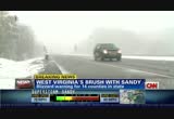
they're definitely doing it at their own risk because it's very dangerous out here. >> now, people in west virginia, ohio, and parts of north carolina, we were all expecting they were going to get snowfall with this storm because of the early reporting from forecasters. but the kind of snowfall they're already witnessing there somewhere in the realm of three feet? is this about what people were ready for and were bracing for there near elkins? >> yeah. i mean, i think that people here are accustomed to nor'easters but nothing of this magnitude. and while it is three feet of snow, it's also three feet of very heavy snow. it's almost like concrete because it's just below freezing. and it's sticking to all the trees. and when we sit here with the car turned off you can hear these like shotgun blasts going off in the distance. and that's as trees are snapping and toppling over from the weight of the snow. it's definitely the real deal out here. and the worst blizzard i've ever chased. we chase much more than just tornadoes. we chase hurricanes, winter storms, and pretty much any form
12:28 am

of extreme weather. >> all right. reed timmer, thank you so much. be safe. appreciate the images and your reporting from there. torrential downpours, whipping winds, flooded roads, this kind of snowfall, it's a little bit of everything. actually, it's probably too much of everything. >> too much of everything. and more is coming, unfortunately. as we said, the snow, sandy dumping a lot of snow. let's get these pictures. these are from west virginia. we just saw what reed was showing us live. but these are the blizzard-like conditions in the town of snowshoe. this superstorm continues, and our coverage of it continues throughout the night right here on cnn.
12:29 am

>> announcer: you never know when, but thieves can steal your identity and turn your life upside down. >> hi. >> hi. you know, i can save you 15% today if you open up a charge card account with us. >> you just read my mind. >> announcer: just one little piece of information and they can open bogus accounts, stealing your credit, your money and ruining your reputation. that's why you need lifelock to relentlessly protect what matters most... [beeping...] helping stop crooks before your identity is attacked. and now you can have the most comprehensive identity theft protection available today... lifelock ultimate. so for protection you just can't get anywhere else, get lifelock ultimate. >> i didn't know how serious identity theft was until i lost my credit and eventually i lost my home. >> announcer: credit monitoring is not enough, because it tells you after the fact, sometimes as much as 30 days later. with lifelock, as soon as our network spots a threat to your identity, you'll get a proactive
12:30 am

risk alert, protecting you before you become a victim. >> identity theft was a huge, huge problem for me and it's gone away because of lifelock. >> announcer: while no one can stop all identity theft, if criminals do steal your information, lifelock will help fix it, with our $1 million service guarantee. don't wait until you become the next victim. you have so much to protect and nothing to lose when you call lifelock now to get two full months of identity theft protection risk free. that's right, 60 days risk-free. use promo code: gethelp. if you're not completely satisfied, notify lifelock and you won't pay a cent. order now and also get this shredder to keep your documents out of the wrong hands-- a $29 dollar value, free. get protected now. call the number on your screen or go to lifelock.com to try lifelock protection risk free for a full 60 days. use promo code: gethelp. plus get this document shredder free-- but only if you act right now. call the number on your screen

12:32 am

images right now. the president being briefed on this superstorm sandy. you can see the daylight hours there at the time. it was hurricane sandy making landfall roughly 8:00 p.m. in the new jersey, new york area. and here the president is with his team getting briefed. >> and you know, for days we've been talking about how big this storm could be, the potential for this storm. and it lived up to all of the estimates. and it lived up to all of the forecasts of being a behemoth,
12:33 am

and it's still happening right now. unfortunately, sandy is as bad as it is, maybe even worse than some thought. damage estimated to be in the billions. you can see here the power of the storm in new jersey. scenes from hoboken. this car crushed. at least 13 people dead in new york alone. 6.5 million people without power. 23 states under high wind warnings and advisories of some sort. and cnn estimates that the damage from just the wind, not the water, just the wind, above $3 billion. and remember the storm has already killed 67 people in the caribbean. >> and then take a look at this, at what's become a fairly typical scene, was roads flooded and cars nearly, you know, engulfed by all that water. about eight hours ago this historic superstorm did make landfall over the most populated area of the united states. wind damage, power outages, storm surges, inland flooding, even snowstorms are threatening
12:34 am
the lives and homes of 60 million people from virginia to massachusetts. >> and imagine living under this. the crane that just swings back and forth over west 57th street in new york. on the right we've got a picture of daylight, what happened after it snapped. on the left you see the way it was supposed to look as it was in the proper position before it snapped. and now it's just swinging in the wind. >> now they have kind of what's called a collapse zone. so an entire seven-block area has been cordoned off so that no one could walk anywhere near it because they really don't know. it's very precarious. they don't know whether that crane will continue to swing because you know, we're talking about wind gusts of roughly between 20 and 40 miles per hour that knocked it into that position, and you still have some pretty sizable wind gusts now. not really sure if it's going to stay in place, what they're going to be able to do. so they've cordoned off that area. >> they've got to clear that area. so let's go to meteorologist
12:35 am

ivan cabrera. he's with us now on superstorm sandy. where is sandy right now? >> sandy is inland right now. and so that is certainly some good news here. we are done with it as far as it being the hurricane here. but we do have a classic nor'easter under way. so it is inland. we are no longer going to be talk about a storm surge as we head through the day tomorrow. we'll be talking about tides coming together. not only has this been a perfect storm, this has been a more perfect storm. the earth, the moon, and the sun even all aligned together to make this a more perfect storm. we'll get to that in a second here. but as far as the latest, again, it is inland now. but the worst is not over for some areas across the interior because we're talking about very heavy rainfall that's going to continue throughout the overnight hours into tomorrow. even the potential, by the way, for severe weather heading up into new england with some thunderstorm activity there. and then of course you saw reed there in the mess that is the middle of a blizzard here as the hurricane married this upper-level disturbance here. and now we're talking about
12:36 am

significant accumulations, upwards of two to three feet. and absolutely, that snow is coming downward. temperatures at the surface are into the lower 30s. so it's that snowman-making snow, having lived in boston for ten years, i can tell you that can cake easily those power lines and create additional power outages. and then of course there's the blinding event as a result of these winds that are still going to be gusting anywhere from 25 to 50 miles an hour. you combine that with heavy rainfall, you combine that certainly with snow, and you're going to be talking about whiteout conditions that will continue. high wind warnings in effect from the entire new england area all the way into the mid-atlantic and down as far south as atlanta where we've here had gusts upwards of 45. that's going to calm down for today and conditions could be a little better for the northeast. but for the interior here this is again going to be a long duration event. we're going to be dealing with very gusty winds and potential for flooding as well along the shores of the great lakes.
12:37 am

take a look at the tides coming up. fredricka and victor, we're going to be watching this closely. the next one coming up for battery park as you know, 9:07 a.m. the last one, had never recorded 13.33 feet at battery park. we did it with this superstorm. that record is likely going to stay in the books, hopefully for a very long time. >> and a late high tide there in new haven, connecticut for noon eastern time. you know, what's remarkable here too is even though it's now over land, it was a hurricane, hurricane sandy as it made landfall, it doesn't keep its name anymore, does it? >> no. at this point we're just calling it superstorm sandy. in fact, the national hurricane center had written their last advisory as of the 11:00 p.m. advisory yesterday. so we're now in a mid-latitude cycle situation here, cyclone that we call nor'easters. it does have that tropical steroid injection of a nor'easter with all that energy coming down from the south. >> and the reason there for the high tides, you're going to explain. >> this is the deal here.
12:38 am

the sun, earth, moon align. we get this twice a month when we get the new moon or full moon. worst case scenario as as far as timing, we had the high tide come in during the full moon yesterday. and of course what that means is that you get additional pull. you get the sun and the moon and the gravitational pull aligning here. you get this bulging that happens on either end of the planet here. this is obviously exaggerated here. we get that additional pull. and so the high tide is higher and the low tide is lower here than we normally get and that's why the flooding was made worse through battery park. now, what i will say is that we're not expecting any storm surge at this point. so this tide is coming in at 9:07. that is not going to be coming in with a storm surge with a landfalling tropical or post-tropical cyclone. as i showed you, this thing is inland now. we are going to still have some gusty winds, and so we are going to see the potential for some minor coastal flooding, some splashover there, but certainly not going to be like what we saw
12:39 am

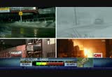
yesterday. >> wow. fascinating stuff. ivan, thanks so much. >> sure. well, new york city firefighters are dealing with more than just sandy. they're also dealing with a massive fire in queens. jeff begaines from a affiliate wnbc, he was on the scene when nearly an entire city block caught fire. and i spoke with him earlier. jeff, thanks for being with us. tell us exactly where you are and what you saw as this all started. >> i'm at a place called rockaway park. and this is a part of queens, essentially an island that's wedged between jamaica bay and the atlantic ocean. and it's south of brooklyn, south of manhattan. and with the storm at high tide tonight both jamaica bay and the atlantic ocean converged and there was water -- it seemed like the water was everywhere. but then another problem popped up, and that was a major fire. there was a fire in this area of
12:40 am
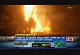
rockaway park that was consuming not only businesses but apartment buildings as well. and this is a flood-prone area. and yet there were still residents here. they hadn't heeded the calls to evacuate. they were here. they were going to ride out the storm. but then this fire happened and members of this specialized new york fire department unit had to go in and rescue them. and i saw these guys. there were about five to ten of them. they were wading through high water. they had a zodiac boat with them. and they had to scale some of these buildings to get to some of the people who were trapped in their apartment buildings. and because of the high water the fire department couldn't get their hoses and any water on these fires. just because it was at the height of the storm. so these members of this specialized unit had to go in
12:41 am

without all that, wade through the high water, some of these buildings, break through windows, get into these apartments, and then usher some of these residents down into the water and then walk them through the water to higher ground. and there wasn't a lot of high ground to find, but they were able to find some, and they got these people out. we're talking maybe as many as 30 to 40 people rescued over the course of about three or four hours. right now as the water has receded, the fire department has been able to get water on this fire. so they're hoping that it doesn't spread further. but one firefighter was telling me that they think maybe as many as four, five buildings have already been consumed by this fire. >> jeff, you say that they're trying to get water on the fire. that leads me to believe it's still burning right now. is that true? >> it is still burning. and the danger is of course that
12:42 am
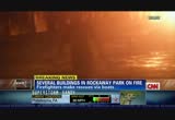
it will continue to spread with the embers blowing in the wind. there are some other fires popping up in the area. and the concern is if they don't get this thing under control and soon it could spread, causing even more damage. >> and it might be too soon to know this because all this is still going on, but about the 30 to 40 people pulled out, are there any other people still missing and the condition -- the conditions of those people who were pulled out. have you gotten any information about that? >> as far as the rescuers that i've spoken with, they think they've been able to get everyone out who was in the path of the fire. i've seen as folks come out. there don't appear to be any serious injuries. maybe minor injuries. nothing too serious. so firefighters believe that they were able to get to these people before it was too late. >> any idea yet how this fire started?
12:43 am
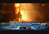
>> well, at the height of the storm it was high tide, about 8:00 here. the water was coming up. the wind was howling. it was blowing. maybe sustained winds around 70 to 80 miles per hour according to some of our meteorologists. and as a result of that, you know, there were power lines that were popping and some of these firefighters that i spoke with suspect that maybe it was electrical, maybe it had something to do with some of the power lines in the area getting blown around as a result of the storm. >> all right. jeff pegues with wabc there in rockaway park where that block in queens is on fire. jeff, thank you. and incredibly, it is indeed still on fire since your conversation with him. >> still on fire. >> yeah. and we're learning now, and you're getting a google map kind of image of rockaway park. now, remember, this was an area that mayor bloomberg said should be evacuated. that was one of that zone a
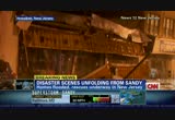
12:44 am
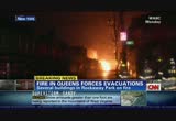
areas. all the rockaways evacuate. so now you've got this fire. you've got 50 homes in all, which is an extraordinary number, that have been devastated, ruined from this fire. >> 50 homes completely gone. 10 still on fire. and this is from the new york fire department. that's where we're getting this. a tweet from that department. and you mentioned just a few moments ago that this is similar to what we saw during katrina. >> that's right. hard to grasp. >> homes on fire. >> and then you've got homes on fire. you saw it in new orleans with katrina. these just spontaneous explosions involving homes. and unfortunately, you've got all this water, and firefighters and first responders can't get that water -- >> yeah. to use it to put -- >> to put on the fire. it's a dangerous situation for them. and this is exactly what the mayor was trying to warn people about. don't put your first responders in danger. but this is the situation here. we're going to have much more of our continuing coverage of this superstorm. next. cross
12:45 am

our t's and dot our i's, we still run into problems. namely, other humans. which is why, at liberty mutual insurance, auto policies come with new car replacement and accident forgiveness if you qualify. see what else comes standard at libertymutual.com. liberty mutual insurance. responsibility. what's your policy? 100% new.
12:46 am

100% mmm... wow, that is mmm... it's so mmm you might not believe it's a hundred calories. new yoplait greek 100. it is so good.

12:48 am

sandy is crippling new england still and parts of the mid-atlantic. >> yeah. a lot of people still dealing
12:49 am
with this. causing massive flooding. especially along parts of delaware's coast. >> that's where gary tuchman is on the ground. rehoboth beach. still holding down the fort filip looks like it's still reagan there. but just a little bit of rain -- i mean just a little bit of wind, correct? >> reporter: well, the wind is -- we still feel the wind, fredricka. but the rain has finally stopped. it really was raining for two days straight and very hard at times. right now i'm walking on the boardwalk here in rehoboth beach, delaware. it's not as famous as the atlantic city, new jersey boardwalk but it's an important part of the fabric of the city. tens of thousands of people come here every week in the summer to go on vacation, rehoboth beach. it's actually a very small town. only 1,300 people live here year round but tens of thousands in the summer, every single weekend, many of them from nearby washington, d.c. and baltimore and philadelphia. and the boardwalk has survived relatively intact. the people here in rehoboth consider themselves very lucky.
12:50 am

here's what we know here in rehobo rehoboth beach. there's some flooding. some homes have been flooded something, cars have been flooded some roads have been flooded. we're also learning statewide in delaware, the blue hen they call, it it was the first state to ratify the constitution, we are being told that 45,000 customers are without power statewide. and this is a small state. you're talking about only one major city, wilmington, you're talking about four beach towns, rehoboth beach, dewey beach, finrock islands. 45,000 people without power after the storms came through. in addition, 30 roads are impassable or are partially blocked. so that's relatively good even though it's a relatively small number compared to new jersey and new york city. new jersey and new york city in that direction. only 45 miles away. that's where the center of this hurricane passed. but the weaker part of the storm hit rehoboth beach, and that's why they seem to be lucky here. the big news, the most important news here, rehoboth beach, delaware, the state of delaware, it appears there are no casualties.
12:51 am

no deaths, no injuries. and that is awfully good news for this area. >> that is good news. but there is inconvenience instead by way of power outages, right? >> reporter: yeah no, question about it. the problem with the power outages, we've been talking about this, this is a very important point to stress. it's a very cold evening, and the people without power, most of them don't have heat. it's a very cold night. so obviously, we all want them to get their power back as quickly as possible because usually we always deal with power failures in hurricanes. but usually, the weather's very hot, people are hot. that's not good either. but they can find ways to get cool. but it's very hard to spend a cold night would no heat inside your home, inside your house or your apartment. >> absolutely right. gary tuchman, thanks so much. in rehoboth beach, delaware. so as predicted, the damage from sandy, it did come in fast, and it could be days before we know the full extent of the damage. in so many locations. >> all up and down the east coast. really 23 states involved
12:52 am

dealing with the wind. even here in georgia they're feeling it. rescues up and down the coast. more pictures. more live coverage. next. [ male announcer ] one in four americans can't sleep.

12:54 am

are you one of them? drink dream water, the natural, fast acting sleep aid that helps you wake refreshed. visit drinkdreamwater.com.

12:56 am

the death toll is going up. unleashing extreme winds and dangerous surge. and now causing whiteout conditions inland. >> i know. unbelievably, now more than 2.1 million people in new jersey are without power. not because of snow but because of rain and high water. police say at least three people have died from fallen trees. and two of those deaths in mendham township about 30 miles west of new york city. new jersey governor chris christie repeatedly warned residents about the potential dangers earlier. >> i'm very disappointed in the fact that some decided to disregard my instruction, in fact my order. and i'm concerned that it might lead to the loss of life. >> also, reports of homes flooded under several feet of water and several rescues have been under way including those stranded under cars while they were trying to escape. >> i'm scared to death.
12:57 am
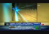
so many people are going to die today. >> authorities are working to evacuate hundreds of people from west atlantic city, where waters are dangerously high as well. so we've been talking quite a bit about new york city. that's the -- of course the highest population area that's been affected by this storm. and we want to give you a visual of the problem facing some city commuters in just a few hours. there will be no commute really. i look at the bridges and the tunnels that link manhattan to the outer boroughs. many are closed across the city. few details are available at this time about any morning commutes or even how businesses, if businesses would even open. and seven new york city subway tunnels are now down due to all the flooding. well, earlier overnight we talked to the mta spokesman kevin ortiz, just how bad things are looking for commuters. >> hurricane sandy has really wreaked havoc on our entire
12:58 am
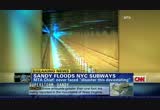
transportation system, pretty much impacting every borough and every county. in the region. as a result of downed trees and loss of power. and obviously, as you can see there, you know, severe flooding in tunnels, rail yards, and bus depots as well. the seven subway tunnels that you referred to that we've seen serious water infiltration are the under-river tubes in the east river that essentially carry a large number of riders to and from manhattan and brooklyn. so we're in the process of trying to assess the extent of the damage down there just to -- in order to begin the recovery process. >> i'd imagine there are pumps trying to get this water out. are these pumps working? and i'm sure it may be too early to say when things will be up and rung. b but is there a no sooner than date that you know of? >> it really is difficult to predict the amount of time that
12:59 am
it's going to take to pump water from these flooded tunnels, bringing equipment as well as adjoining stations back into service. it really does depend on what we see down there with regards to the height of the storm surge and how rapidly, you know, we can pump water out of there. you know, we've got pump rooms. we've got portable pumps. we've got pump trains. but that being said, it's still going to take some time to get the water out of there. and depending what we see, it can range anywhere between 14 hours to four days just to get water from these tunnels. >> so again, trains will not be running in many parts of lower manhattan, and it's still difficult to know how the rest of the subway system is being impacted by this because you've got so much water, many feet of water that have flooded some of these tunnels, and it's also meant that it has also impacted the electrical, but the power grid there in lower manhattan, which affects so much of all of manhattan and the other boroughs. >> and for the rest of the east coast, dealing with the snow and the wat
231 Views
IN COLLECTIONS
CNN (San Francisco) Television Archive
  Television Archive News Search Service
  The Chin Grimes TV News Archive
Uploaded by TV Archive on
